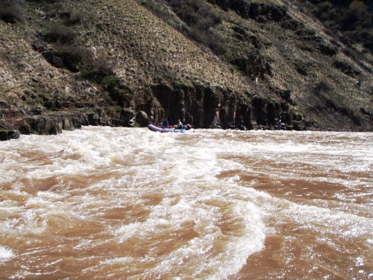
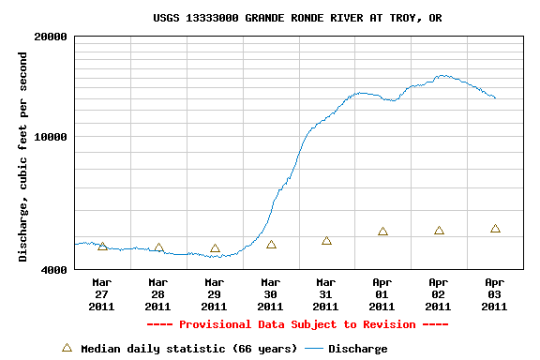
By the time we got to the take out, flows on the Grande Ronde River had tripled and reached record levels. Rafting a whitewater river while it spikes makes for a powerful ride.
My rafting partner Kevin and I played the river flow and weather forecast game the week before our planned float on the Grande Ronde River (Minam to Heller Bar). By the time we decided the trip was a go three days before launch and even up to the day before our launch, the river looked to be steady around 4500 cfs for a few days and rising to about 7000 cfs on our last day. The weather was supposed to be rainy on launch and then partly sunny the rest of the time we were out. Warning – the river flow and weather forecast game should be played for entertainment purposes only.
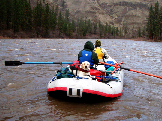
It rained on us the night before the launch — us being Kevin, Marc, Jemma the River Dog, and myself. That night was a bit auspicious. Well after midnight a couple ya-hoos rolled into the Minam State Park campground blaring Bob Marley. And well before dawn some ya-hoo fired off a rifle a few times. So much for a good night’s sleep the night before a float. The rain let up in the morning but started again as we finished rigging the boats and didn’t stop all day.
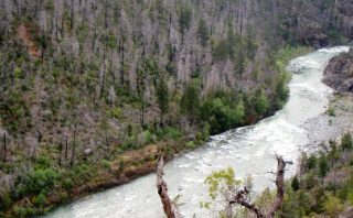
The 91-mile Grande Ronde float is actually a trip on three rivers through two states. You start out on the Wallowa River in northeastern Oregon, then float the Grande Ronde from Oregon to Washington, and take out on the Snake River in southeastern Washington. Marc suggested we make it a four river trip. If we pulled the boats upstream a hundred yards, we could launch on the Minam River just above its confluence with the Wallowa. We didn’t.
The headwaters of the Grande Ronde River lie in the Elkhorn Mountains of Oregon. The headwaters of the Wallowa River lie mainly in the Eagle Cap Wilderness in the Wallowa Mountains. Elevation drops from 2500 feet above sea level at Minam to 825 feet at Heller Bar with an average river gradient of 19 feet per mile. The upper river from Minam to Troy is characterized by steep, rugged canyons with mixed conifer forests and grassy ridges. In the lower river below Troy, the river broadens and transitions to an arid, rocky, desert canyon. The river flows continuously with few eddies, especially at higher flows. The eight named rapids are rated Class II-IV. There are also many unnamed rapids and riffles along the river. The rapids change in difficulty with the change in river flows. All river trips require a self-issue permit, which you can get at the information kiosk at the Minam boat ramp.
Day One
As we headed down the Wallowa, the river felt shallow. I scraped the oars on the river bottom occasionally and bumped along over submerged gravel bars. I’m still not sure exactly where the Minam Roller Rapid (Class I-III) was. This is the first named rapid on the float that the BLM guide describes as “a large wave develops in center stream proportionally to the river flow.” Maybe it was at the bend in the river and small cliff as we went by the Minam State Park campground.
Red Rock Rapid (Class II-III), the next named rapid, is true to its name. A large red rock about the size of a shed sits in the center of the river. The line just to the left of the rock was pretty clear. And then you stay close to the rock to avoid the hole river left. At the flow we were seeing, you could easily have run the hole and had a big splash coming out. We didn’t.
Jemma bounced off the boat and took a swim at Blind Falls Rapid (Class II-III), the next named rapid. That’s what you get, I guess, for walking around on the tubes in a rapid. The BLM guide describes this one as, “Sudden drop over rock shelf with narrow channel in the middle of the river.” I didn’t notice a sudden drop, but there were rocks and waves. And a surprised dog.
Once onto the Grande Ronde, Sheep Creek Rapid (Class II-III) was the last named rapid we encountered. The BLM guide: “Located just below Sheep Creek. River turns slightly to the left prior to the beginning of the rapid. Several exposed rocks or large waves in rapids.” We noticed there was quite a bit more water in the river once we got on the Grande Ronde. I didn’t notice any exposed rocks in this rapid but we did have some large waves. Nice.
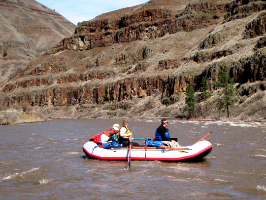
We made camp that afternoon vicinity river mile 75 on the bench river right just before the river makes a sharp right turn. At high flows, getting off the river was quite a task. Since there were two in our boat, our strategy was to land Marc and I first and for one of us to hold the boat while the other ran and caught Kevin as he came in. There weren’t any eddies to float into and casually get out of the boats.
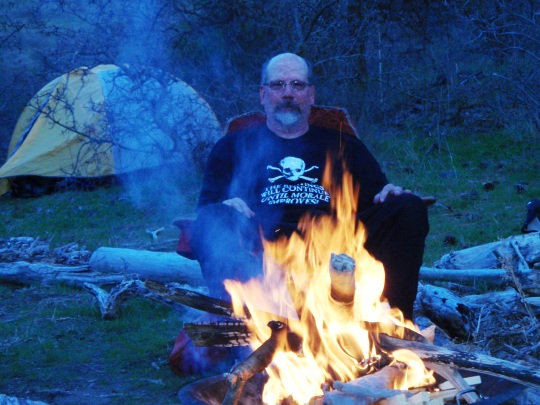
Camp was on a long, grassy bench above a gravel bar. Kevin had a large 20×30 foot tarp we set up between some pines. Kevin and Marc put their tents up under the tarp because of the rain and the questionable water tightness of their cheap, “sporting goods store” tents. I trusted my REI Half Dome and set up out in a clearing. I had the better site. The rain broke that night and they got to listen to the continuing drip off the trees. They thought it poured all night. Before we went to bed, we pulled the rafts up high on the gravel bar and double checked they were tied up securely. Good thing we did. The river rose significantly that night.
Day Two
Since we had only floated 16 of 91 river miles so far, we all agreed we should make about 30 miles that day. The river was agreeable. As we launched, I could tell the river had a lot more push.
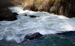
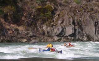
We enjoyed some fast current and wave trains before coming to the first named rapid of the day, Martins Misery Rapid (Class II-III). The BLM guide describes the rapid as “large standing waves and rock hazards.” At high flows (the river was above 10,000 cfs by now), we could see a few rocks but mostly big waves. We also talked that morning about the high water and the consequences of a mishap and a long, cold swim. There weren’t many eddies for someone in the water to swim to and get out of the current and out of the river. So, we chose not to run the big waves opting for caution and staying dry and warm over thrills.
We floated through the new rapid at river mile 64 without knowing we had. To us, it pretty much looked like the waves and fast current we had been running all morning. The BLM has an alert for this rapid on their website. The rapid was created by a creek washout in early 2010. Jemma bounced off the boat and swam again in this stretch of water. This time she was turning around on the gear in the stern when a little wave sent her in. Fortunately, she came back to the boat instead of trying for shore as there were big waves ahead and a possible long hike for her to catch back up with the boats wherever we managed to get to shore.
The wildlife viewing for several miles above Powwatka Bridge was rich. We quit trying to count the number of white tail deer and mule deer. We saw two herds of elk, two herds of bighorn sheep, redtail hawks, and bald eagles. Double Eddy Rapid (Class I-III) was just what the BLM guide called it, “sharp S-curve causing strong eddies.” We maneuvered through boils and sucks doing our best to stay out of the eddies – would have been a lot of work to row out of those.
As we passed Troy, we had made our 30 miles for the day and it was afternoon. Time to start thinking about a camp. The camps just below Troy are not choice. Most are right next to a road that is apparently pretty well traveled for a remote river canyon road. We tried to make the camp river left between river miles 41 and 40 but weren’t able to get across the river current. For plan B, we hugged river right and beached on the rock bank just past the island at river mile 39. This involved jumping out of boats, dropping lines, grabbing lines, cursing, and scrambling. Then we inspected the camp – rocks, brush, small trees. Not nice.
We were at the up river end of the bench. Jemma and I went for a scout. The dog needed to run. At the down river end of the bench there was just the slightest bit of slack water and enough space around a reforestation project for tents and a kitchen area. About 34 river miles for the day. Home for the night.
Day Three
The next morning greeted us with blue skies and few clouds. Breakfast and breaking camp were leisurely as we dried out gear and tents and basked in the sunshine.
Eventually we got moving down the river. And wouldn’t you know it. Two miles down river just around Horshoe Bend was a nice camp river right. Tall pines, grassy bench. Maybe next time.
Although we encountered no named rapids, just about every bend in the river came along with fast currents and big waves. The character of the river had certainly changed. The river was wide. The countryside was dry. The only pines were pretty much in draws and ravines.
We stopped at Boggan’s Oasis to refill water cans. Marc and I made the boat ramp. The current placed Kevin in the first eddy below Boggan’s. While I brought the water and dog back to the boats, Marc checked the info in the store. The river was running over 13,000 cfs.
Camp was at Deer Creek near river mile 19 that afternoon. Our first river camp with a true eddy to pull into. The dog entertained herself in the eddy. When someone wasn’t throwing a stick in the water for her to fetch, she went after the bits of wood that were drifting in it. She seemed to know to stay out of the fast current at this and the other camps. That evening we watched a group of bighorn sheep and a pair of nesting redtail hawks across the river. We watched the stars, then some sheet lightning, and then it started sprinkling. Time to go to bed.
Day Four
The morning was wet. Breakfast, breaking camp, and getting on the river went quickly. The river was also going quickly.
A flock of wild turkeys flew over us and across the river. I never thought of turkeys as the flying type. We watched a pair of nesting bald eagles near river mile 11. Between river mile 12 and 11 are some great camps river left — flat bench, a few pines, and no roads.
We started watching the river and the map closely. The Narrows (Class IV) is the big rapid on the river and the big one for the day. We wanted to scout it before running it if we could. River mile 11 was easy to pick out — sharp bend in the river, flat bench, jeep trail. Then the map and the landscape weren’t matching up very well. “Wait a minute here, we’re coming up on river mile 6 and it hasn’t even been an hour.” The Narrows is at river mile 5.
There was no place to scout. Meaning, there was no way to pull over and land in order to scout. The BLM guide: “Basalt lava flow where river channels into narrow chute. Rapid characteristics change dramatically. Rapids consist of powerful waves, eddies, and turbulent water. Be cautious of rattlesnakes and prickly pear cactus.” Marc and I went first (Marc rowed – just happened to be his turn) and Kevin followed. We scouted from the boat. Massive waves down the middle of the river and a sneak line in slow water and eddies river left of the waves. We took the sneak line. Those were the tallest, continous waves I’d ever seen. Kevin said he could see the waves crest well above our heads as we worked our away across the slower water. Maybe six to eight feet high.
We took a break on shore above the next section of the rapid. Jemma discovered that the prickly pear the BLM cautioned about in the guide were not in the rapid. She was rolling in the sand and rolled into some prickly pear. She jumped up looking for what bit her. She’d never met a cactus before. I pulled a few needles from her rump later.
I rowed the next bit below The Narrows. Driftwood and strainers to avoid and some roller coaster waves. Roller coaster waves at Bridge Rapid (Class II-III) as well. A mile or so before the takeout was a fish trap boat on a cable working river left at the bottom of a nice wave train. Sign said they’d be there all summer. That could prove tricky if rafts and fish trap are in the wave train together. We toasted another great river trip and finished our last three beers at the take out at Heller Bar on the Snake River.
The shuttle drive back to Minam took us through Boggan’s Oasis. We stopped for lunch. The store owner checked the current river flow online for us: over 15,000 cfs. And, yes, we had been the only ones on the river. Cheeseburgers never tasted so good and the Grande Ronde has never run so big (well, in river gage recorded history anyway).