Saturday morning and we gather with friends from Ambotovy International School at a boat landing on the Pangalanes Canal. We’re going south on the canal for 60 kilometers (37 miles) to the Le Palmarium resort. A friend has organized the excursion for the nine of us through a tour agent at a cost of about 300,000 ariary per person ($150) which includes the round trip boat ride, one night in the resort, meals, and a guided hike through the forest to see lemurs.
Typically, the tour starts from a dock in Toamasina. But the canal runs by our village, so we walk ten minutes to the landing, which is simply a cleared area on the banks of the canal. We meet Pascal, the captain of our boat from Le Palmarium, and Bambino, our guide for the weekend.
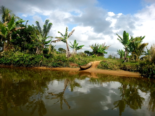
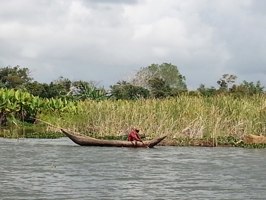
We board. Pascal fires up the engine and we’re off. It’s a cool morning and rains a little bit. The drone of the boat’s motor is loud enough to make conversation difficult. So I watch the landscape. Forest, villages, rice paddies, people, pirogues (dugout canoes), fishermen, a few motorboat taxis.
Canal History
For those of us close enough to hear him, Bambino tells some history of the canal. The Pangalanes Canal links together natural rivers and lakes and runs about 600 kilometers (370 miles) from Toamasina south to Farafangana along the central section of the east Madagascar coast. The canal was constructed under the governance of the colonial French between 1896-1904 to provide transportation of goods to the trading center at Toamasina since shipping along the coastal Indian Ocean was very dangerous. The workers on the canal were primarily Malagasy and Chinese, many of whom died during construction from malaria and crocodiles.
Crocodiles? Where? Bambino says most of the crocodiles have been hunted out of canal waters but a few are still around. They are mostly out at night. Night swims under the moonlight are out.
I get an “into the jungle” remote feeling as we chug along. There are few motorized boats and few mobile phone towers or other signs of the industrial world. To the west somewhere in the hills is Route National 2, to the east sand dunes and the Indian Ocean. A north to south rail line runs somewhere between the canal and lakes and the sand dunes. But I don’t know if trains still run on it.
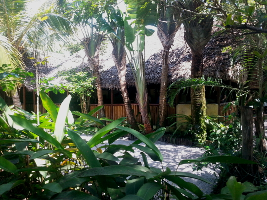
Le Palmarium
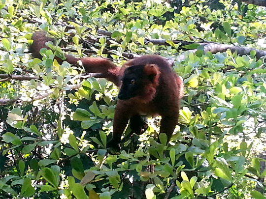
Three hours of chugging and we arrive at Le Palmarium. We disembark, check in, and gather for a leisurely and delicious lunch. An almost black lemur comes by looking for handouts but doesn’t get any (I haven’t yet figured out which species this one is).
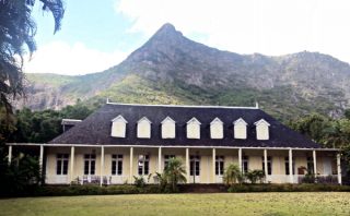
Le Palmarium also called Ankanin’ny Nofy, Malagasy for “nest of dreams,” is situated on a 50 hectare reserve (about 123 acres) on the shores of Lake Ampitabe. The buildings feature traditional constructeion for the most part. The restaurant and reception are under a large, ravenala (traveler’s palm) thatched roof with sides open to air. The bungalows have hot water (wood heated) and a generator provides power into the late evening. Always nice to have a hot shower and be able to charge modern can’t-live-without gadgets. On the ample verandas of the bungalows are chairs, a table, and a hammock.
After lunch, some of our group trek to a local village. They say later it was a bit epic. Heat, hills, and creek crossings. Not me. I take a nap then explore the gardens and the beach.
Dinner is excellent. The menu is a mix of Malagasy and French-influenced international dishes. After dinner, women and children from a local village perform traditional dances. Some guests are challenged to a dance where they balance a bottle on their heads. I avoid that one.
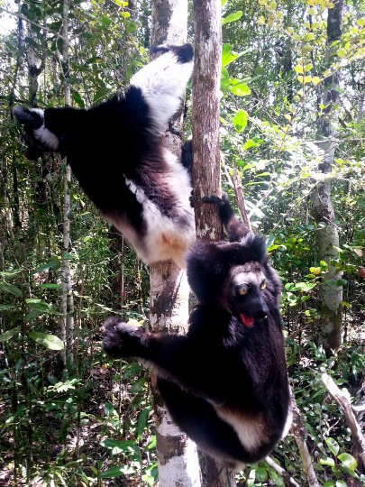
Lemurs
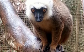
During breakfast, several lemurs show up. Lori offers one a slice of banana. First one then another jumps on her, “Please, may we have some more.”
After breakfast, Bambino and a Le Palmarium guide take us on a walk through the gardens and then the forest. The gardens showcase native Malagasy plants like ravenala, the Madagascar or Traveler’s Palm, local crops like vanilla and pineapple, and a few radiata tortoise. In the forest, our Le Palmarium guide calls in lemurs. We see indri, black and white ruffed, and crown lemurs, and a reddish hybrid lemur. I feed an indri who very gently holds my hand, lifts it, and eats the slice of banana from my palm.
Then comes a drowsy boat ride home after lunch in the sunshine.

I enjoyed your post from 10/25/13. I was going to take issue with you use of the phrase “a bit epic”. I thought, ‘How is something “a bit epic”? Isn’t that like being “a bit pregnant”? ‘ Thinking into it further though I decided that an experience could have epic elements in a compressed time frame. I compared it with some of my own adventures and came to the next realization. Your use of the phrase caused me to think much further into your story, to conjure up images of your story subjects’ travel and relate them to some of my own. Your device worked……..damn you!
The other issue I will take you to task for is the fact that you told us that you eschewed a few kilometer walk in warm weather for a ride in a car and that your feet have been toughened to the point of your having eschewed hiking boots for flip flops or bare feet. Your blog logo uses a hiking boot print. Time to think about a change for the sake of accuracy? Eschew on that for a while.
Godspeed my friend.
Ouch. Thanks for the constructive comments and keeping my writing honest. That’s what friends are for, eh? Sorry for the long reply that folows.
Part 1. Glad you worked it out about the “bit epic” thing. I’ve found a trip, a hike, or river run can be entirely epic or have moments of epic-ness. I’ve also found epic-ness to be pretty personal based on ones own experiences, expectations, and comfort levels . Maybe epic-ness is also in how good of a story comes out of the experience. Lori and our friends thought they were going on a short walk to a village. The heat, hills, creek crossings, distance, and mosquitoes (the last two I didn’t mention in the blog) provided a good story later. I should’ve added to the story that Bambino, our guide, said beforehand it’s an easy walk to the village. And after said, well, it’s easy for Malagasy. Malagasy walk a lot.
Part 2. I think you’re referencing my just published A Wednesday Drive to Tuesday. You have warm weather back there in western Oregon. And cold weather which I miss. I thought I’d been in heat before. Like summer rafting on eastern Oregon rivers. And hiking in the deserts of southern California including through the edge of the Mojave. Madagascar is hot. I think there are two seasons here – hot and hotter. Or maybe one season of hot and rainy and the other hotter and rainier (at least for the east coast where we live). And in the Highlands around Antsirabe it gets hot in the day and cools off at night. I would’ve melted walking those “two kilometers.” Maybe I should add a little on the culture here. Malagasy want to be helpful. So, even if they’re not sure about an answer, like how far to the basket workshop, they’ll give you an answer. It took us a half hour to get there driving at 10 mph or so. Distance was likely five miles there, ten miles round trip. Would’ve made for an “epic” afternoon in the heat. I was being ironic about the soft feet thing and whether mine are tough now. I’ve got some pictures in an upcoming post that will show what tough feet really means. BTW, that’s a trail shoe print in the logo. I don’t wear hiking books on trails. Trail shoes make for happier and healthier feet. Here as well as in Southeast Asia I hike in Chaco sandals. My daughter Ashley hiked something like 700 miles of the Pacific Crest Trail in Chacos including a chunk of the desert and through the Sierra Nevada Mountains. But I digress. I’ve thought of switching the logo to a flip flop.
Good to hear from you.